8 Minutes to Addressing
Last week I was watching a(nother) emergency-services documentary, "8 minutes to disaster", charting the trials and tribulations of an ambulance crew around Reading. The titular time-frame refers to the central mandated target (grumble government bureaucracy grumble) of how long the crews have between receiving a top-priority call and getting to the scene of the incident. In amongst much of the usual diabolical behaviour of drunken idiots in proximity to the NHS, there was one scene in particular that struck me. Mainly because I see most things through an OpenStreetMap filter nowadays, but...
The ambulance crew were responding to one such high-priority call, to respond to house 54 on a street of which I can't remember the name. They had been told it had a brown door, and when they found house 53 with the other half of the semi having a brown door, they jumped out and started pounding on it. A few seconds later a neighbour helpfully pointed out that it was an unmarked "53a", so they jumped in the ambulance, and set off again. Finding house 54 further down the street, they again jumped out, but the wrong colour on the door gave the first indication they were now on the wrong street, so jumping back in the ambulance and taking the other fork in the road got them to the correct house 54, with a brown door, and when they finally got to the patient, he was dead.
Now admittedly the patient in question had been dead for a few days, so 3 minutes of faffing around didn't cause him any significant ill effects, but when the first scene of the program was a man quite literally bleeding out, it shows such things can make all the difference. And I was surprised that the crew didn't have some massively overcomplicated, Accenture-procured multi-million pound GPS system that had house numbers built in. Actually, now I think about it, it's probably best they didn't - having been involved in the periphery of a few NHS IT projects, I can say they are the best way yet conceived of turning gob-smackingly large amounts of taxpayers money into things that simply just don't work. So these paramedics are probably better off with a consumer device that other consumers have willingly chosen to pay for with their own hard-earned cash, rather than involving bureaucrats, even though it can't help them find particular houses in a timely manner. I've seen similar issues on other emergency-services documentaries - police getting stuck in housing estates due to barriers simply not on their commercial GPSes.
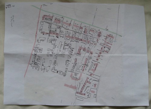
So the OpenStreetMap tie-in comes from having spent the last few weeks starting to look into what comes next for OpenStreetMap after we've mapped every road, pub and cycle route in the country (hey, what seemed wildly ambitious just two years ago is becoming increasing routinely anticipated), and what's technically known as "Addressing" is part of that. It involves taking things one step further than just knowing where each road is, and getting to the point where we know where each house on each road is. Now that's a whole lot of work, but in bits and pieces across Europe OSM volunteers are starting to try things out. Dave has made a start around our area - see his sketch above - which is made up of fiendishly complex blocks of flats and Matt has done some stuff near our office. Frederik and Jochen from GeoFabrik have even made a tool for helping spot mistakes in the data. There's a lot of potential here, but a lot of hard work, but with everything in OSM it's a case of when, not if.
So here's hoping that in the next year or two we'll see consumer devices working from the world's best global community-generated open-source mapping-cum-routing-come-addressing-cum-everything-else dataset, helping ambulance drivers (and pizza delivery guys, for that matter) from here to, well, everywhere. And maybe it'll be only a few years between us saying "OpenStreetMap is pretty accurate, but I wouldn't use it for routing ambulances" to saying "OpenStreetMap is pretty accurate, especially for routing ambulances". It'll be awesome.
This post was posted on 12 November 2008 and tagged OpenStreetMap, Transport