ASTER - Not worth it yet
A few months ago NASA caused a stir by releasing a new global height dataset called ASTER. I use an earlier dataset (SRTM) for OpenCycleMap, which has a few problems that ASTER, at least initially, promised to solve. The three of primary interest to me are:
- Voids - SRTM has "no data" gaps in certain places of the world, where the radar reflections went haywire. These happen in marshes (not of interest) and mountains (of great interest!), especially over the Alps. ASTER is void-filled already, so the clever-but-inaccurate void-filling I use wouldn't be necessary
- Resolution - It's great that SRTM covers the whole world, but I'd love to see it at a higher resolution. ASTER's nominal resolution is three times greater than SRTM, so it's very attractive.
- Arctic coverage - SRTM only goes as far north as 60°N, which is a bit of a problem in Scandanavia. Although there's GTOPO30 data for these areas, that's got a horizontal resolution measured in kilometres, so not exactly great for me. ASTER covers those areas too, up to 83°N.
So far so good. But when I started work with ASTER in December, things spiralled rapidly downhill. First is the pointlessly irritating "order a dataset" website, that sucked up hours of going round in circles. It's like a shopping website from 1999. You need to use a stupid interface to order which 1°x1° tiles you want, and "All" isn't an option, despite there being 22,600 of them. It seems geared up for people who want a couple of dozen at a time, and the whole thing has a feel of being run by men with beards and sandals who'd rather you didn't use their website in anything newer than Netscape 4 on HP-UX.
When I read the README alarm bells started ringing. There's a section on "mole runs" and "pit artefacts" that sounded a bit worrying, but I wasn't sure how much of an issue they'd be - if they were small and few and far between then that's not much of a problem. But the biggest thing that caught my eye, buried on page six after pages of confirmation of how good the accuracy was, right at the end of a section as a throwaway comment, was the following statement:
Also, while the elevation postings in the ASTER GDEM are at 1 arc-second, or approximately 30 m, the detail of topographic expression resolvable in the ASTER GDEM appears to be between 100 m and 120 m.
That's a bit of a bomb-shell - it's saying that although it's got a much higher nominal resolution than SRTM, it's effective resolution is about the same - there's not any more actual detail, just more pixels. That was almost enough to make me give up there and then, but it's still void filled and covering more area of the planet, which would be good improvements. So I grabbed the DEM (thankfully, they're straightforward GeoTIFFs) and got to work over Snowdon. I did some colouring and contours, and they both looked excellent and much better than what I made from SRTM. But then I tried hill-shading, and disaster!
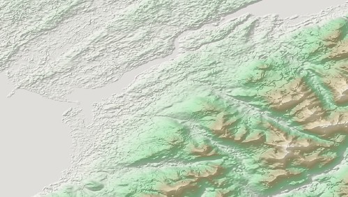
Here's the area around Snowdon (click through for original size):
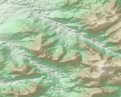
and a detail of Snowdon itself:
The mole runs are everywhere - all across that image, even on the flat bits. And the pit artefacts are huge - the size of quarries, and really, really obvious. I honestly can't use that - maybe for a "what the world would look like if it looked like the moon" project, but nothing more serious than that. And considering that SRTM has only a handful of single-pixel voids in that area, the guys making ASTER have made something that's substantially worse than an oversampled SRTM. And considering they were even using SRTM to fill the gaps in the ASTER data, that's a pretty poor show. I started reading around and found a few people saying similar things. And when I though about it, the "improvements" to the contours I saw could be recreated with SRTM by using gdalwarp to artificially increase the resolution (with some nice smoothing) before generating the contour lines. So I gain nothing from ASTER in the 95% of the planet that doesn't have significant voids, and in that same 95% it's not really usuable.
So for now, I've given up with ASTER. I might revisit it for the band between 60°N and 83°N, but it also says in the readme they have voids over eurasia for that area (so much for void-filled, eh?). And it would be interesting to see if someone can fill the large SRTM voids with ASTER (which sounds back to front, hey-ho), but I don't have time for that. However, as they say in the docs, all these artefacts are happening in the boundaries where they have different numbers of original samples, so maybe a future version will have these automatically smoothed out, and it they can figure out how to stop their 15m sampling getting turned into 120m effective resolution, that would be awesome. But for now I would say it's not worth using it.
This post was posted on 13 January 2010 and tagged General

