Tiger Edited Map resurrected
Recently I've been working with MapQuest to rebuild the OpenStreetMap "Tiger Edited Map". It was publicly released last week (blog, link).
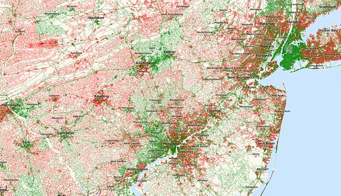
The original map was created by Matt while he was at CloudMade, but it disappeared not long after we left at the end of last year. This is a from-scratch reimplementation with a few bonus features - it's updated every few minutes, and the stylesheets are available on GitHub. It uses osm2pgsql with extended attribute information to enable styling by openstreetmap id and date ranges (see the nitty-gritty here) - and a word to the wise: don't turn on extended attributes for nodes unless you have infinite hard drive space and patience to go with it!
It's great to see how much progress there's been this year, and it shows where we need to check for the usual TIGER issues. One of the interesting things for me is that it shows a recognisable editing pattern across the entire US - the major roads have all been edited (most multiple times), as have vast swathes of urban areas - enough that OSM is a distinct enough dataset from TIGER to stand out on its own. Hopefully this will inspire more people to fix up the streets in their own areas and drive the quality of OSM data in the US upwards - step by step. My next plans along these lines is to work on the Rapid Assessment Tool I made some time ago - moving along the QA debate from the origins of the data (I believe we're often too hung up on the word "TIGER") and onto assessing how good OSM data is on its own merits.
If anyone has any suggestions for improvements to the style - especially changes to the detection algorithm, or similar ideas for other regions - then I'd love to see either forks from the git sources or even plain old comments below!
This post was posted on 27 October 2010 and tagged OpenStreetMap