Posts
- The whole of Europe rendered to zoom level 8. That should help spot any national routes cropping up around the place, and gives quick gratification if anyone starts in a new country
- The whole of the Netherlands down to zoom level 13. That means even local routes will show up, and at the lowest zoom it'll flick over to route highlighting. Some short sections are already available - the LF1 north of Vlissingen and more routes on the outskirts of Eindhoven
- A collection of routes around Stockholm - there's more national route some distance to the north east, but that wasn't there last week when I set up the render boundaries so you'll have to wait for a few more days!
- ncn4 effectively completed between London and Wales with the addition of the Marlborough to Trowbridge section, and extended into Wales towards Newport
- ncn16 appearing between Bishop's Stortford and Braintree
- The 46 appearing and the 5 being completed south of Birmingham
- More of the ncn68 through Hartington
- Regional Route 10 south of Bristol
- ... and a huge amount of work around Newcastle - there was nothing there last time I looked!
- Extension of ncn 3 through Taunton and Tiverton
- The ncn 5 completed from Reading to Oxford
- Another short section of the ncn 6 south of Leicester, and more further north near Lancaster and Milnthorpe
- A short extension to the ncn 4 and some of the ncn 61 around Windsor, Eton and Slough
- New higher-zoom (z15) areas around Edinburgh and Bristol
- Non-toucan crossings rendered as yellow dots, as seen along the Ipswich Ring-road
- Sustrans "Regional Cycle Routes" now rendered in a lighter shade of blue, to distinguish them from Local cycle networks, as seen in the greater Ipswich area and in the impressive coverage of Kent
- Various little tweaks to the rendering styles
- The extension of NCN 4 from Staines to Windsor
- The appearance of a stretch of the NCN 41 north-east of Stratford-upon-Avon
- Three short stretches of the NCN 6 - along the Grand Union Canal near Acton, further north near Watford and finally on the southern approach to Harpenden
- ... and probably other places that I didn't notice. It was much easier to spot the additions a few weeks ago when there were hardly any routes on show!
- Mapperz - The mapping news blog: “A nice implementation ‘in progress’ using free data. A positive move to community based mapping and you can see the results from this map.”
- Google Earth Design - an interview with Steve Chilton, Chairman of the Society of Cartographers : “One of the most impressive recent niche sites, although a work in progress, is a cycle-specific map site where the OSM data has been customised.”
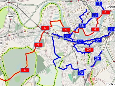
- Yahoo Answers - Cycling into central London: “Here’s the cycle map for Putney through to Battersea.”
Reuse and Prosper
So my cycle map here on Gravitystorm isn't likely to become the world's one stop cycle website any time soon. I don't have the time, and I certainly don't have the skills, to add all the bells and whistles to attract megathousands of pagehits per day. So what's the long term strategy?
Who knows? Not me anyway! For now, I'm going to continue to work on the cycle tiles, making them look better, showing more useful things that cyclists might be interested in - eagle-eyed observers would have noticed one of the first changes I made was to show pubs at many more zoom levels! There's plenty of things in the pipeline in this area.
One of the main beneficiaries of the cycle map is the OpenStreetMap project itself, since it acts as a great demonstration as to the possibilities of specialist cartography - something that's just not possible with layering more and more objects over the top of a google map. But the best way for cyclists to benefit is for their own, specialist websites to swap google for OSM. The first two websites to reuse my tiles are Bonius.com, and the excellent Camden Cycle Campaign website, where the OSM cycle tiles are an optional backdrop. Hopefully the coverage of the cycle data in central and north London will rapidly expand - if we can do that, I think we can persuade the CCC to use our OSM tiles as the default layer!
So if any of you reading this know of other websites that could benefit from better cycle maps, then let me know. I can already think of one mountain biking route map (like the link, Gary?) that would be ten times better if it could show nearby pubs!
This post was posted on 1 December 2007 and tagged OpenStreetMapOSM Cycle Map Goes International
After a request from one of my OSM colleagues in the Netherlands, and with some mooching around the planet checking for any other signs of cycle routes, I've expanded the cycle map rendering to show more places at high zoom. Added this week:
And I've noticed there's some in Oslo too, so that'll get more detail hopefully in next week's render pass. I've also added an extra layer over the entire of the UK, so you can view all the areas in even closer detail. There's still only some areas done to the maximum depth (London, Bristol and Edinburgh amongst them) so feel free to ask. I'm going to have to look into avoiding rendering vast amounts of sea - the tileset is now gigabytes in size.
I'm hoping that the motto "render and they will tag" will apply to the Netherlands in particular - already you can use the maps to highlight all the cycle paths, and adding in the national, regional and local signed routes will make things even better. Get tagging NL!
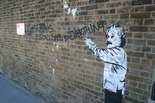
This post was posted on 26 October 2007 and tagged OpenStreetMapA Wise Man is Astonished By Everything
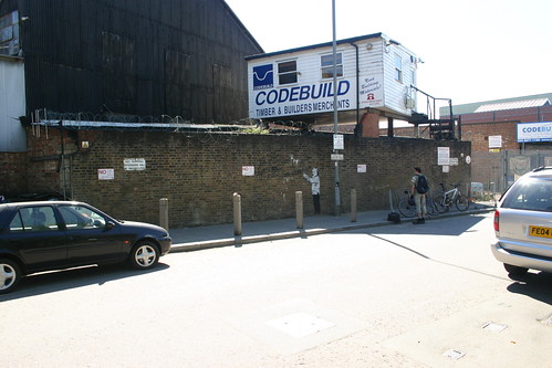
A few months ago I was cycling home along Smuggler's Way near the Wandle Delta when I spotted some graffiti on the wall of a builder's mechant. A few weeks later I stopped off to get some photos.
Not a Banksy, I don't think, but cool none the less. Unfortunately it looks like the uber-efficient Wandsworth Borough Council anti-graffiti squad have removed all traces of it, which is a shame. I bear no grudge against the squad - who I must owe a bottle of wine to by now for the number of times they've responded to my pleas regarding graffit on our estate - but a part of me wishes they could make a distinction between art and vandalism.
On an entirely unrelated note, here's a nice chirpy song for you - "Youkou Yeah Yeah !" from Vulsor's The Project. Keen followers of my last.fm profile - which records for posterity what I listen to at home - would have noticed this getting a few plays since I found it in my collection. I'd recommend "Mushroom" from the same album, except I hate how it ends. When I get a chance (and err, learn how...), then I'll remix it and give it a proper conclusion....
This post was posted on 24 October 2007 and tagged Culture, Open Culture, PhotographyDusk 'til Dawn 2007
It's probably about time I write some non-openstreetmap stuff!
Last weekend was the Dusk 'til Dawn overnight mountain bike race around Thetford Forest. 844 competitors in a couple of hundred teams (with some idiots doing a 12 hour solo race, and more sensible people like us doing relays in teams of four), and a course just under 12 miles long winding around the forest - some single track (fun, but tricky for overtaking), some fire road (i.e. forestry track), and the occaisional "bomb hole" thrown in for good measure. We came 32nd in our class (full timings) with me doing the first, seventh and final laps of the night.
The first lap had an, umm, interesting start. Grimey was doing the first leg, but came running back into the camp half an hour in with a UST flat that he hadn't been able to fix. So I piled on my bike and rattled off round the course, in solitary bliss, 30mins behind everyone else. With the fastest expected to complete the laps in around 45 minutes I knew they'd be bearing down on me by the time I made it round - practise laps had taken over an hour during the week. About two thirds of the way round I started to catch the very back markers and fly past them, and from the timing and speed differential some of them thought I was in the lead and lapping them! They might have noticed that fast as I was, it would have been nothing compared to the steam trains that were following.
I made it round about 30 seconds before the first placed team crossed the line, and then had several hours off whilst Gary and Ade got into an alternating pair routine. Next time, I need to remember ear plugs to get some sleep without the noise of all the generators around the campsite. I got no sleep at all, and eventually got up and played at team manager for both our team ("Bowl of Petunias") and the B team ("Cambridge Consultants", 46th overall), trying to keep track of who was out, when they left, what their ETA was, and who needed waking when to take over. Oh, and arguing with the guys in the charging tent who couldn't seem to cope with the idea that everyone else in the teams were either cycling or asleep.
My second lap was during the witching hours, and it was quite quiet. I think any team that wasn't cycling for the full twelve hours was probably taking a break, so my lap was again fairly empty, but this time with the nutters overtaking me. I thought my pace was dropping hugely (the adrenaline of the frantic first lap was sorely lacking) but from the timings it was actually pretty good. The dense fog was a bit disconcerting - blasting along at up to 18 mph with about two bike lengths of visibility in some places. And getting quite cold, too.
Everyone had another go, and the timings fell for me to do the final lap and take us over the 12 hour mark. By this point it was daylight, and as much as I wanted to keep using the headlights (4 x 5W LEDs, sweeet) they weren't having any effect. It was quite weird doing it when it was light, but by that time I knew the route off by heart, and the track was somewhat wider, smoother and firmer than when we'd started practising three weeks ago.
Great fun. Highly recommended.
Some (daylight) photos on Gary's website
mphotography: [1] [2] [3] [4] [5] [6] [7] [me] [9] [me] [11]
This post was posted on 11 October 2007 and tagged LifeThe World Conspires
The world conspires to prevent me updating the cycle map - from the ever (and rapidly) increasing amount of data in the db (the "planet" files are now around three times larger than when I started a few weeks ago, and growing at about 200Mb per week) to disk failures in the famous beerwarmer, which is the machine that pre-renders the tiles before uploading.
This week's update is so late that it could be mistaken for next week's, which is a pity, since huge amounts have been added - probably several hundred miles of cycle routes. Amazing! Highlights include:
If I've missed anything, or you want to stake a claim to any of the hard work, then just pipe up!
All in all, I'm constantly amazed by how much stuff gets added to the cycle map each week (never mind all the non-cycle work). In only a couple of months it's gone from sparse data to a functioning network map. As was apparently pointed out on IRC earlier this evening, you can now get between major cities on our routes. I don't think it'll be much longer before OSM becomes the definitive online map for the national cycle network, never mind all the towns and cities that are gaining detailed local maps too.
Here's a little teaser for something else I'm working on...
This post was posted on 1 October 2007 and tagged OpenStreetMapCycle Map - 13th September
I haven't changed any rendering yet (despite promises to Richard about the national byway), but I might get a chance to do that later this week. For now, it's only the routes that have been added:
For the last one, Dave and I actually cycled to Uxbridge, so there's still more to add. But with the TIGER import running and the continuing expansion of the database, tagging is becoming a pain as everything grinds to a halt. Hopefully either Dave or I will put the rest of the 61 into the database before too long.
This post was posted on 13 September 2007 and tagged OpenStreetMapCycle Map updates
New this week in rendering:
More importantly, new routes spring up all the time. This week includes:
The NCN 6 is an interesting one - Dave and I cycled the Grand Union stretch on Saturday, and I wonder who did the other two bits further north - were there three groups all working independently this week on the same route? As more and more of the routes have at least some of the sections marked, the next task will be to join them all together.
If anyone has any other areas that they want higher detail rendered, or spot any other new sections recently added, feel free to leave a comment.
This post was posted on 6 September 2007 and tagged OpenStreetMapCycle Map in the news
My Cycle Map has been pretty well received so far…
The last one is my favourite really, since it’s just two guys talking about cycling, and using the map for what it’s meant for. I’ll need to head over to Battersea and extend route 37 onwards… Hopefully more and more people will find it genuinely useful as well as just cool.
Oh, and of course, the cycle map made the featured image on the front page of the OSM wiki for the week beginning 11th August.

Nice. And to think when I commented only two months ago “roll on a cycle-focussed version of OpenStreetMap!” that I had no idea I’d be the one making it happen!
This post was posted on 30 August 2007 and tagged OpenStreetMapCycle Map Quote
Richard Fairhurst, professional cartographer and one of the lead developers of OpenStreetMap, talks in his OSM diary about my cycle map:
Andy Allan's Mapnik map of the National Cycle Network is pure genius and the best example yet of why mashups suck, and cartography matters.
Now that's the kind of response I like to hear!
This post was posted on 4 August 2007 and tagged OpenStreetMapTrack of the Week
For your audio pleasures, my favourite track for this week is the uninspiringly-named "Piste 08" in Xcyril's album "Organique". Very upbeat, well rounded, pick-me-up kind of music.
If I was producing a TV show I'd be very tempted to use it as the signature tune, and with only a little editing of the ending to remove the forced staccato in one of the phrases, I'd be quite happy. Oh, and since it's cc-by-sa, I'd be allowed to edit it, and use it commercially too!
This post was posted on 3 August 2007 and tagged Open Culturesubscribe via RSS


