Tag Archives: OpenStreetMap
- Cycle shops. Evan's Cycles in Wandsworth is where I've spent more money than sense over the last year, so it now gets pride of place and a special mention here. There's a total of 50 bike shops in the database now that shop = bicycle has been decided on.
- NCN Mileposts. For those who haven't seen them, there are mileposts scattered around the National Cycle Network. Gregory Williams has been mapping (and photographing them for a while now, and his efforts are rewarded by seeing all 83 of them on the cycle map. Each of the four types has its own icon!
- Improved railways. Perhaps the most noticeable of the non-cycle updates, railways have had a major update thanks to the improvements on the main maps - tunnels are taken into consideration, for a start, but also more subtle greys instead of blacks. Areas like Camden look much better.
- The whole of Europe rendered to zoom level 8. That should help spot any national routes cropping up around the place, and gives quick gratification if anyone starts in a new country
- The whole of the Netherlands down to zoom level 13. That means even local routes will show up, and at the lowest zoom it'll flick over to route highlighting. Some short sections are already available - the LF1 north of Vlissingen and more routes on the outskirts of Eindhoven
- A collection of routes around Stockholm - there's more national route some distance to the north east, but that wasn't there last week when I set up the render boundaries so you'll have to wait for a few more days!
- ncn4 effectively completed between London and Wales with the addition of the Marlborough to Trowbridge section, and extended into Wales towards Newport
- ncn16 appearing between Bishop's Stortford and Braintree
- The 46 appearing and the 5 being completed south of Birmingham
- More of the ncn68 through Hartington
- Regional Route 10 south of Bristol
- ... and a huge amount of work around Newcastle - there was nothing there last time I looked!
- Extension of ncn 3 through Taunton and Tiverton
- The ncn 5 completed from Reading to Oxford
- Another short section of the ncn 6 south of Leicester, and more further north near Lancaster and Milnthorpe
- A short extension to the ncn 4 and some of the ncn 61 around Windsor, Eton and Slough
- New higher-zoom (z15) areas around Edinburgh and Bristol
- Non-toucan crossings rendered as yellow dots, as seen along the Ipswich Ring-road
- Sustrans "Regional Cycle Routes" now rendered in a lighter shade of blue, to distinguish them from Local cycle networks, as seen in the greater Ipswich area and in the impressive coverage of Kent
- Various little tweaks to the rendering styles
- The extension of NCN 4 from Staines to Windsor
- The appearance of a stretch of the NCN 41 north-east of Stratford-upon-Avon
- Three short stretches of the NCN 6 - along the Grand Union Canal near Acton, further north near Watford and finally on the southern approach to Harpenden
- ... and probably other places that I didn't notice. It was much easier to spot the additions a few weeks ago when there were hardly any routes on show!
- Mapperz - The mapping news blog: “A nice implementation ‘in progress’ using free data. A positive move to community based mapping and you can see the results from this map.”
- Google Earth Design - an interview with Steve Chilton, Chairman of the Society of Cartographers : “One of the most impressive recent niche sites, although a work in progress, is a cycle-specific map site where the OSM data has been customised.”
- Yahoo Answers - Cycling into central London: “Here’s the cycle map for Putney through to Battersea.”
The Bike Show
Last night's episode of "The Bike Show", aired on London's Resonance FM, featured an extended interview with your's truly on the subject of OpenStreetMap and my OSM cycle map. The interview was recorded out and about around London a couple of weeks ago - and if you want to listen to it, it's available on their website - "Reclaim the Street(maps)".
Also on the programme was a short interview with George Coulouris and Jean Dollimore from the Camden Cycle campaign. We've been collaborating over their mapping website, maps.camdencyclists.org.uk, to use my cycle maps as the backdrop to their routes, and you can switch from Google to OSM using the drop-down in the top right corner of their maps.
So those of you paying attention to the interview will know who finished off the LCN 22 a couple of weeks ago!
This post was posted on 5 February 2008 and tagged OpenStreetMapLife on the bleeding edge
No, thankfully not a direct reference to my week of snowboarding, but the "bleeding edge" is a techie term for being so close to development that things go wrong as often as they go right. Which is more or less how the cycle map has been over the last fortnight.
Dave has bought new bits and pieces for the infamous "beerwarmer", the server that does all the work behind the cycle map, and written lots of clever code to take advantage of the quad core processor - to the point where 726,795 tiles takes only 1hr29m to render. But the biggest improvements have been in the mapnik rendering library, making great improvements to the text placement handling and semi-transparent layering options. I've no idea whether people will notice things like cycle shops and toucan crossings now showing above the route highlights (see Putney for example), or much better displaced-text (see Stockholm) but it's the little things that improve the quality, and with the recent work we've been doing with the mapnik developers there's now many more bits of polish that can be applied.
There's yet more areas added to the cycle map, including Trondheim in Norway and Bern in Switzerland. As ever, if there's anywhere else in the world that you want rendered, please let me know. I try to keep an eye on where national cycle routes are appearing, but I don't always notice all of them.
And my snowboarding trip didn't go unnoticed - a few worried people piped up on the mailing list to enquire what was going on with the lack of updates - no rest for the wicked!
This post was posted on 3 February 2008 and tagged OpenStreetMapOSM Cycle Map on my GPS
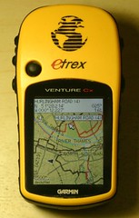
Sound familiar? Not quite. A year ago I posted about putting an OSM map of putney on my GPS. Six months ago I started doing the whole bike map thing, so now there’s significant amounts of cycle routes in the database - several thousand kilometres’ worth. And today, thanks to some work by Richard Fairhurst, I get to combine the two:
OpenStreetMap seriously kicks ass. I don’t know of anywhere else that you can get cycle-customised garmin maps, for free. Whenever anyone wonders why we bother with OpenStreetMap, HERE’S YOUR ANSWER. I’ll probably start distributing the gmapsupp.img files for anyone who’s interested. Thanks to Richard, Steve Radcliffe, Computerteddy and of course everyone who’s ever contributed cycle data to the project.
Oh, and it’s a serious pain in the ass trying to get good photos of a GPS - you should have seen the hassle I went through to get this looking better than the last one!
This post was posted on 13 January 2008 and tagged OpenStreetMapCycle Map - 6th December
Last weekend I finally got a chance to work on the rendering styles for the cycle map. The major work was to realign with the recent developments on the main OpenStreetMap style, as well as adding a few new cycle-specific features. Worthy of note:
For a while I'd been giving updates on new cycle routes being added, but that was back in the days when I could spot the weekly additions on a somewhat sparser map! Personally, this week I've added a stretch of the NCN 61 from Slough to Uxbridge, added more un-numbered London Cycle Network routes in Roehampton and West Putney and fixed up the NCN 22 through Wandsworth. The latter is interesting due to the appalling signing of the route - the "Wandle Trail" forms part of the NCN 22 and the LCN 24, and I think there's about one correct sign between Wandsworth and Carshalton - most of them mistakenly have "24" in the NCN signage! Dave bumped into someone from Sustrans who was going to be sorting this out, but I've no idea how far they've got since we cycled it a few months ago.
In related news, Cambridge Cycle Campaign have just published a City Centre cycle map using OpenStreetMap data. It's given me a few ideas for adding things to my cycle map - you compare this with the equivalent area of Cambridge.
I'll also be at the OSM Christmas Party tomorrow night!
This post was posted on 6 December 2007 and tagged OpenStreetMapReuse and Prosper
So my cycle map here on Gravitystorm isn't likely to become the world's one stop cycle website any time soon. I don't have the time, and I certainly don't have the skills, to add all the bells and whistles to attract megathousands of pagehits per day. So what's the long term strategy?
Who knows? Not me anyway! For now, I'm going to continue to work on the cycle tiles, making them look better, showing more useful things that cyclists might be interested in - eagle-eyed observers would have noticed one of the first changes I made was to show pubs at many more zoom levels! There's plenty of things in the pipeline in this area.
One of the main beneficiaries of the cycle map is the OpenStreetMap project itself, since it acts as a great demonstration as to the possibilities of specialist cartography - something that's just not possible with layering more and more objects over the top of a google map. But the best way for cyclists to benefit is for their own, specialist websites to swap google for OSM. The first two websites to reuse my tiles are Bonius.com, and the excellent Camden Cycle Campaign website, where the OSM cycle tiles are an optional backdrop. Hopefully the coverage of the cycle data in central and north London will rapidly expand - if we can do that, I think we can persuade the CCC to use our OSM tiles as the default layer!
So if any of you reading this know of other websites that could benefit from better cycle maps, then let me know. I can already think of one mountain biking route map (like the link, Gary?) that would be ten times better if it could show nearby pubs!
This post was posted on 1 December 2007 and tagged OpenStreetMapOSM Cycle Map Goes International
After a request from one of my OSM colleagues in the Netherlands, and with some mooching around the planet checking for any other signs of cycle routes, I've expanded the cycle map rendering to show more places at high zoom. Added this week:
And I've noticed there's some in Oslo too, so that'll get more detail hopefully in next week's render pass. I've also added an extra layer over the entire of the UK, so you can view all the areas in even closer detail. There's still only some areas done to the maximum depth (London, Bristol and Edinburgh amongst them) so feel free to ask. I'm going to have to look into avoiding rendering vast amounts of sea - the tileset is now gigabytes in size.
I'm hoping that the motto "render and they will tag" will apply to the Netherlands in particular - already you can use the maps to highlight all the cycle paths, and adding in the national, regional and local signed routes will make things even better. Get tagging NL!
This post was posted on 26 October 2007 and tagged OpenStreetMapThe World Conspires
The world conspires to prevent me updating the cycle map - from the ever (and rapidly) increasing amount of data in the db (the "planet" files are now around three times larger than when I started a few weeks ago, and growing at about 200Mb per week) to disk failures in the famous beerwarmer, which is the machine that pre-renders the tiles before uploading.
This week's update is so late that it could be mistaken for next week's, which is a pity, since huge amounts have been added - probably several hundred miles of cycle routes. Amazing! Highlights include:
If I've missed anything, or you want to stake a claim to any of the hard work, then just pipe up!
All in all, I'm constantly amazed by how much stuff gets added to the cycle map each week (never mind all the non-cycle work). In only a couple of months it's gone from sparse data to a functioning network map. As was apparently pointed out on IRC earlier this evening, you can now get between major cities on our routes. I don't think it'll be much longer before OSM becomes the definitive online map for the national cycle network, never mind all the towns and cities that are gaining detailed local maps too.
Here's a little teaser for something else I'm working on...
This post was posted on 1 October 2007 and tagged OpenStreetMapCycle Map - 13th September
I haven't changed any rendering yet (despite promises to Richard about the national byway), but I might get a chance to do that later this week. For now, it's only the routes that have been added:
For the last one, Dave and I actually cycled to Uxbridge, so there's still more to add. But with the TIGER import running and the continuing expansion of the database, tagging is becoming a pain as everything grinds to a halt. Hopefully either Dave or I will put the rest of the 61 into the database before too long.
This post was posted on 13 September 2007 and tagged OpenStreetMapCycle Map updates
New this week in rendering:
More importantly, new routes spring up all the time. This week includes:
The NCN 6 is an interesting one - Dave and I cycled the Grand Union stretch on Saturday, and I wonder who did the other two bits further north - were there three groups all working independently this week on the same route? As more and more of the routes have at least some of the sections marked, the next task will be to join them all together.
If anyone has any other areas that they want higher detail rendered, or spot any other new sections recently added, feel free to leave a comment.
This post was posted on 6 September 2007 and tagged OpenStreetMapCycle Map in the news
My Cycle Map has been pretty well received so far…
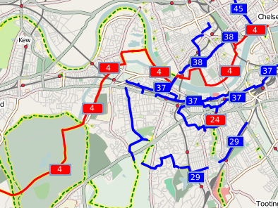
The last one is my favourite really, since it’s just two guys talking about cycling, and using the map for what it’s meant for. I’ll need to head over to Battersea and extend route 37 onwards… Hopefully more and more people will find it genuinely useful as well as just cool.
Oh, and of course, the cycle map made the featured image on the front page of the OSM wiki for the week beginning 11th August.

Nice. And to think when I commented only two months ago “roll on a cycle-focussed version of OpenStreetMap!” that I had no idea I’d be the one making it happen!
This post was posted on 30 August 2007 and tagged OpenStreetMapsubscribe via RSS

